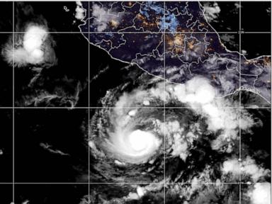
When twin tropical powerhouses light up satellite feeds on opposite sides of the world, meteorologists don't just watch—they hold their breath. Right now, two separate ocean basins are dealing with major severe weather threats. Hurricane Trudy is bearing down on Mexico's Pacific coast, while Typhoon Champi is aiming its sights directly at Guam.
If you live in these regions, or if you track global storm patterns, you know how quickly things change. Let's break down where these storms stand, why the danger is unique right now, and what coastal communities are doing to brace for impact.
Hurricane Trudy Targets the Mexican Coast
Hurricane Trudy has rapidly transformed into a serious meteorological threat. Tracking northwest at roughly 8 mph, the system has positioned itself roughly 240 miles west-southwest of Acapulco in the Mexican state of Guerrero, and about 215 miles south-southeast of Manzanillo in Colima.
According to the U.S. National Hurricane Center, Trudy is expected to drop heavy rainfall across the weekend. We're talking 4 to 8 inches of rain broadly, with isolated totals hitting up to 15 inches in vulnerable spots.
"The Mexican navy urged the maritime community and coastal residents to exercise extreme caution due to high waves, heavy rains and the risk of rising river levels, flooding and landslides in vulnerable areas."
What makes Hurricane Trudy particularly dangerous isn't just the raw wind speed or rainfall totals. It's the antecedent soil moisture. Officials in Colima and surrounding areas point out that successive storms have already battered the Pacific coastline in recent weeks. The ground is thoroughly saturated. That means even moderate downpours can trigger flash floods and devastating landslides long before the storm's core makes landfall.
Typhoon Champi Threatens Guam With Catastrophic Force
Halfway across the world in the western Pacific, the threat is equally intense. Typhoon Champi is charging westward at roughly 15 mph, packing maximum sustained winds around 130 mph according to the U.S. Weather Service. That makes Champi the equivalent of a Category 4 Atlantic hurricane—and forecasters warn it could easily upgrade to a super typhoon.
A typhoon warning is currently in effect for Guam and Rota, while tropical storm warnings cover Tinian, Saipan, and surrounding island communities.
The rainfall forecast for the Marianas is staggering. While Tinian and Saipan are bracing for 3 to 5 inches and Rota prepares for up to 8 inches, Guam is staring down the barrel of over a foot of rain. Flood watches are active across the board. Because Champi is projected to pass just south of Guam, the island's infrastructure will feel the severe squeeze of intense winds and torrential downpours for hours on end.
Why Simultaneous Pacific Threats Stress Emergency Systems
Handling one severe tropical system is tough. Managing two major storms across different time zones stretches international forecasting and disaster response networks to their limits.
When you look at the big picture, these events highlight a few hard truths about coastal preparedness:
- Saturated ground changes everything: Standard rainfall metrics fail when the earth cannot absorb another drop.
- Island geography amplifies wind damage: Small islands like Guam face intense storm surges and wind shear with zero natural buffers.
- Speed matters: Trudy's slower movement allows it to dump excessive water over prolonged periods, whereas Champi's high winds pack an immediate, destructive punch.
Local authorities are urging residents to secure loose outdoor objects, stay off coastal roadways, and heed evacuation notices immediately. If you're in the path of either system, stop waiting for the storm to look worse out your window. Prepare your emergency kit, secure your home, and follow official local guidance right now.