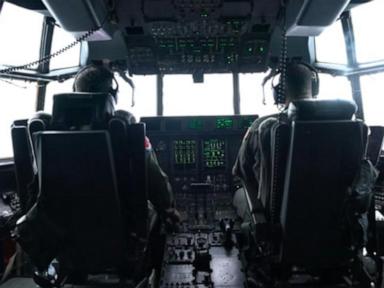
Most people watch a major tropical system from the safety of their living room couch, glued to local weather updates while heavy rain batters the windowpanes. But a specialized group of aviation crews and atmospheric scientists head straight for the danger zone. When Hurricane Isaias intensified, flying commercial aircraft away from the danger path wasn't enough; specialized military and civilian crews intentionally drove heavy-duty turboprops right into the boiling core of the storm.
Flying directly into a hurricane looks nothing like your typical turbulent commercial flight. It's a calculated, high-stakes mission executed by the NOAA Hurricane Hunters and the Air Force Reserve's 53rd Weather Reconnaissance Squadron. If you've ever wondered what it's really like inside a storm of this magnitude, you have to look past the computer models and look straight at the radar displays inside a Lockheed WC-130J Hercules or a NOAA WP-3D Orion.
Why Satellite Data Isn't Enough
Satellites orbiting hundreds of miles above Earth provide breathtaking imagery of swirling cloud shields, but they can't tell forecasters what's happening at the ocean surface. They miss the critical barometric pressure drops and wind shear shifts occurring beneath the cloud canopy.
That's where direct reconnaissance changes everything. When a hurricane intensifies rapidly—like Isaias tracking toward the Gulf Coast—forecasters need exact numbers. They need to know the minimum central pressure and the peak sustained wind speeds right now, not an hour ago.
Pilots fly these rugged aircraft straight through the eyewall, where violent updrafts and downdrafts toss the plane around like a leaf in a gale. Once they punch through that aggressive wall of wind and rain, they enter the eye. It's a surreal experience. The turbulence drops off instantly, blue sky or stars often appear overhead, and towering walls of clouds surround the aircraft in a phenomenon known as the stadium effect.
Deploying Dropsondes and Gathering Real-Time Data
Once inside the eye, flight meteorologists release dropsondes—cylindrical instruments equipped with parachutes, GPS, and sensors that measure pressure, humidity, temperature, and wind velocity all the way down to the ocean surface.
This raw data feeds directly into National Hurricane Center computer models. Without these metrics, hurricane tracks and intensity forecasts would carry a much higher margin of error. When Isaias threatened coastal communities, every single pass through the center provided the data needed to adjust evacuation orders and warn residents about incoming storm surges.
Common misconceptions suggest that flying these missions is reckless or purely a thrill-seeking exercise. In reality, it's a precision scientific operation. Crews train rigorously to handle structural icing, severe turbulence, and electrical lightning strikes. They rely on advanced radar systems to navigate around the most violent convective cells while still capturing the core metrics required for public safety.
The Human Element Behind the Forecasts
Behind every hurricane warning alert on your phone is a team of tired pilots, navigators, and meteorologists working out of bases in Mississippi and Florida. They fly consecutive 10-hour missions into punishing weather so emergency managers have accurate data before landfall.
Next time you track a hurricane heading toward land, remember the crews cutting through the troposphere to measure the storm's pulse. Their work separates a catastrophic surprise from a prepared community.
Hurricane hunters fly into heart of Isaias as storm gains strength in gulf
This video provides an authentic look at the reconnaissance missions flown directly into the core of Hurricane Isaias as it intensified over the Gulf waters.
http://googleusercontent.com/youtube_content/1


