The United Nations just issued a stark warning about the Pacific Ocean, and you should probably pay attention. A major El Nino event is strengthening rapidly and heading straight for a powerful peak this coming December. According to the World Meteorological Organization, this cycle could rank among the strongest witnessed since record-keeping began in 1950.
When sea-surface temperatures in the central and tropical Pacific spike, the consequences ripple across the entire planet. Global weather patterns shift, jet streams warp, and communities everywhere brace for extreme disruptions. This isn't just another routine weather fluctuation. It's a massive transfer of thermal energy from the ocean straight into the atmosphere, operating on top of already rising baseline global temperatures.
What Makes This El Nino Different
Let's be clear about how this works. El Nino doesn't manufacture heat out of thin air. Instead, it acts as a giant valve, releasing heat that has been stored deep inside the ocean directly into the sky.
The oceans right now are warmer than anything we have ever measured in modern history. Because the baseline energy pool is so massive, this developing event has far more fuel to burn than previous cycles. WMO Secretary-General Celeste Saulo pointed out that the sheer volume of available heat changes the game for atmospheric reactions.
Climatologists look at sea-surface temperature anomalies in the central and eastern equatorial Pacific to gauge severity. A standard El Nino requires a sustained rise of 0.5 degrees Celsius above average. Current models from the National Oceanic and Atmospheric Administration suggest we are looking at anomalies that could easily cross the two-degree threshold, placing this event into the "very strong" category with high statistical confidence.
The Real World Fallout
Weather extremes don't care about diplomatic borders. As the Pacific warms up, regions that rely on predictable rainfall face severe risks of drought, while other areas prepare for devastating floods.
Take agriculture and food systems, for instance. Key crop producers across Asia, Australia, and parts of the Americas are staring down potential yield reductions in critical staples like rice, wheat, and grains. When major grain exporters experience prolonged droughts or unexpected monsoonal failures, global commodity prices react instantly.
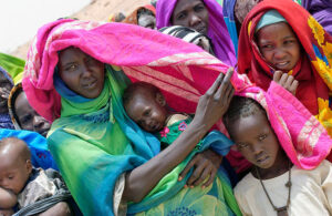
Vulnerable populations bear the heaviest burden. UNICEF estimates that over 340 million children across nearly 100 countries will face direct exposure to extreme weather shocks through the end of the year and into early 2027. In parts of the Greater Horn of Africa, excess rainfall triggers flash floods and spreads water-borne diseases, while places like Colombia and the Philippines face acute water scarcity.
Preparing for the Peak
We know the peak hits in December, but the aftershocks will linger well into spring 2027. Governments and humanitarian organizations are scrambling to implement anticipatory action programs, shifting away from reactive disaster relief toward proactive defense.
History shows that every dollar spent on disaster risk reduction saves multiples in recovery costs down the line. Yet, funding for proactive preparation remains remarkably low. As we head into the winter months, expect headlines about erratic storms, shifting commodity prices, and broken temperature records. Keep an eye on local advisories, because this climate cycle is rewriting the rules in real time.